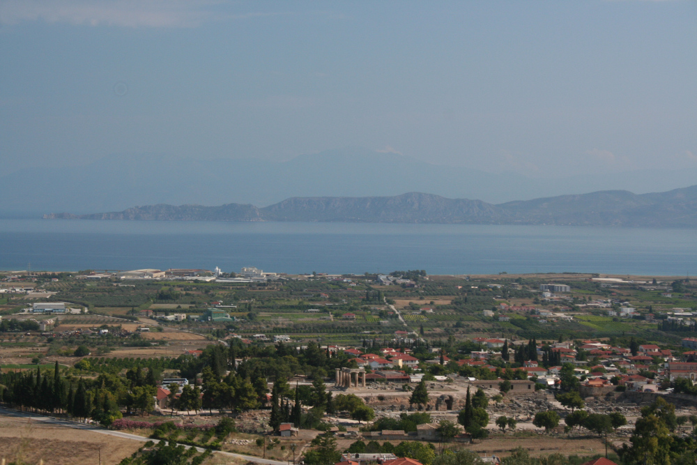
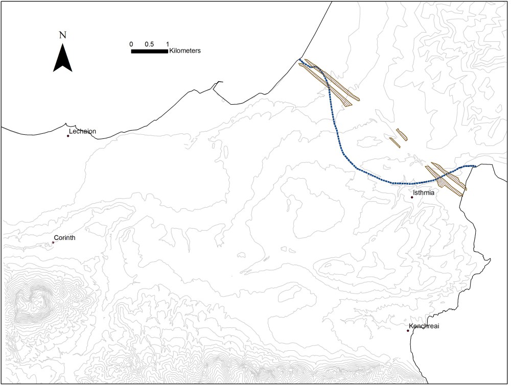
Geography is one of the keys for understanding Corinth’s prosperity and influence. The isthmus at Corinth has always been a meeting place of east and west, the crossroads at the narrow land bridge between central Greece and the Peloponnese, and between the Gulf of Corinth and the Saronic Gulf. Tyrants and traders, pilgrims and prostitutes took advantage of the twin harbors at Lechaeum and Cenchreae, the sanctuary of Poseidon at Isthmia, and the commercial and civic center at Corinth to create one of the most important city-states in ancient Greece. It is no wonder that ancient writers gave the epithet ἀφνειά, “wealthy,” to Corinth.
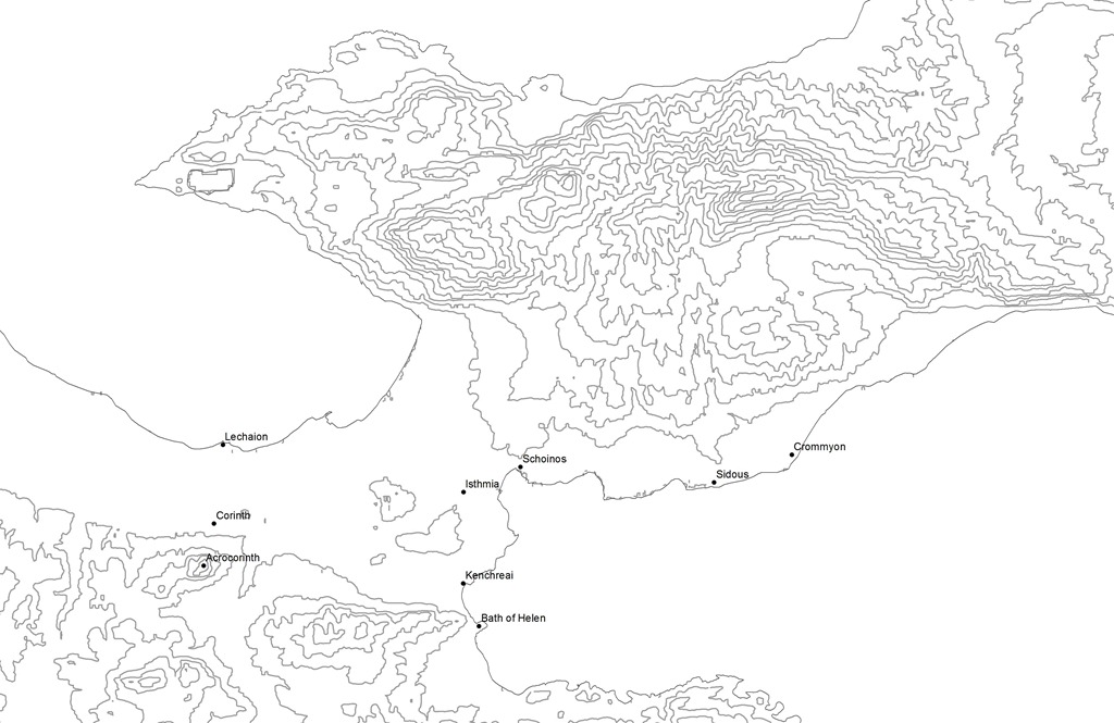
The land of the ancient Corinthians actually encompassed territory on both sides of the isthmus. On the Peloponnesian (south) side, the Corinthian polity extended from the Saronic Gulf on the east to the Nemea River on the west and as far south as the town Tenea. North of the isthmus, Corinthian territory included Cromyum (on the road from Athens and Megara) and the sanctuary of Hera Acraea at Perachora (“the land beyond”) on the promontory north jutting into the Gulf of Corinth. And just south of ancient Corinth, the fortified citadel of Acrocorinth (573 masl) dominates the landscape and acts as the “fetters of Greece” (Polybius 18.11.5; Jameson).
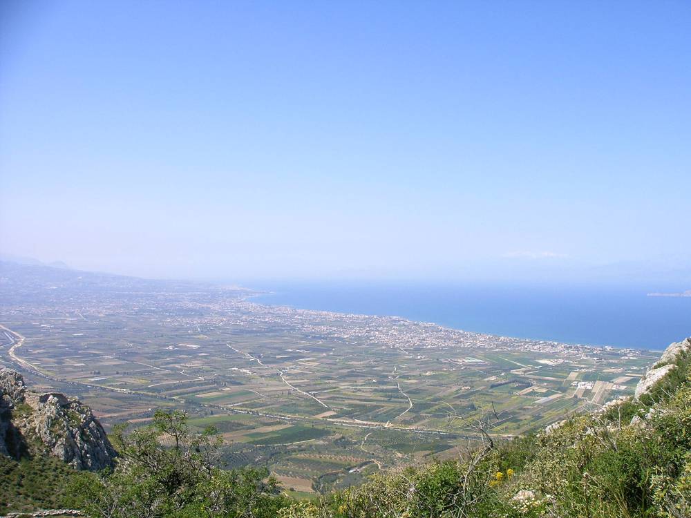
In addition to fertile land, outstanding clay for ceramics, limestone for building, and skilled metalworkers, two ports bring in additional wealth. Corinth’s western harbor, Lechaeum, 3 km north on the Gulf of Corinth, received goods Italy and the west while Cenchreae, 8.5 m east of Corinth on the Saronic Gulf, was the hub for trade from Asia:
Now this latter [Cenchreae] they use for the trade from Asia, but Lechaeum for that from Italy. Lechaeum lies beneath the city, and does not contain many residences; but long walls about twelve stadia in length have been built on both sides of the road that leads to Lechaeum. (Strabo 8.6.22)
Because of Lechaeum’s proximity to Corinth, the Corinthians built two long walls along the road from Corinth to the port. In all, the city walls around Corinth, Acrocorinth, and Lechaeum measured 10,000 m (Jameson). And the Romans greatly enhanced the harbor, constructing three long moles that created a protection for the harbor and framed a series of basins entered by a narrow waterway (Sanders). Given its location closest to the most fertile land in the Corinthia, its proximity to Corinth itself, and the number of western colonies tied to Corinth, it is not unreasonable to assume that Lechaeum was Corinth’s major port.
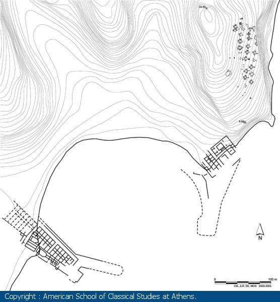
Unlike the “sparsely-settled” Lechaeum, Cenchreae, farther away to the east, developed a sizable settlement on the south slopes of the promontory that helped protect the harbor. Indeed, the Roman novelist Apuleius in the second century CE described Cenchreae as “busy with a multitude of people” (Metamorphoses 10.35). Like Lechaeum, the Romans enhanced the harbor at Cenchreae with moles and also constructed warehouses, commercial fishtanks, and sanctuaries to Asclepius and Isis (Scranton et al.; Rife). In Apuleius’ novel, the Egyptian goddess Isis appears to Lucius (transformed into an ass) at Cenchreae and instructs him how to transform himself into human form once again by plucking roses in the procession celebrating the Navigium Isidis, the first day of sailing in the spring. Besides temples to Isis and Asclepius, inscriptions and literary texts attest to cults of Aphrodite, Dionysus, Pan, and Poseidon. It was from Cenchreae, moreover, that the apostle Paul set out in c. 50 CE for Syria after cutting his hair in fulfillment of a vow (Acts 18:18). And Cenchreae must have been the site of a Christian community since Paul mentions a woman named Phoebe who is described as a διάκονος and προστάτις of the early Christian church at Cenchreae (Romans 16:1-2).
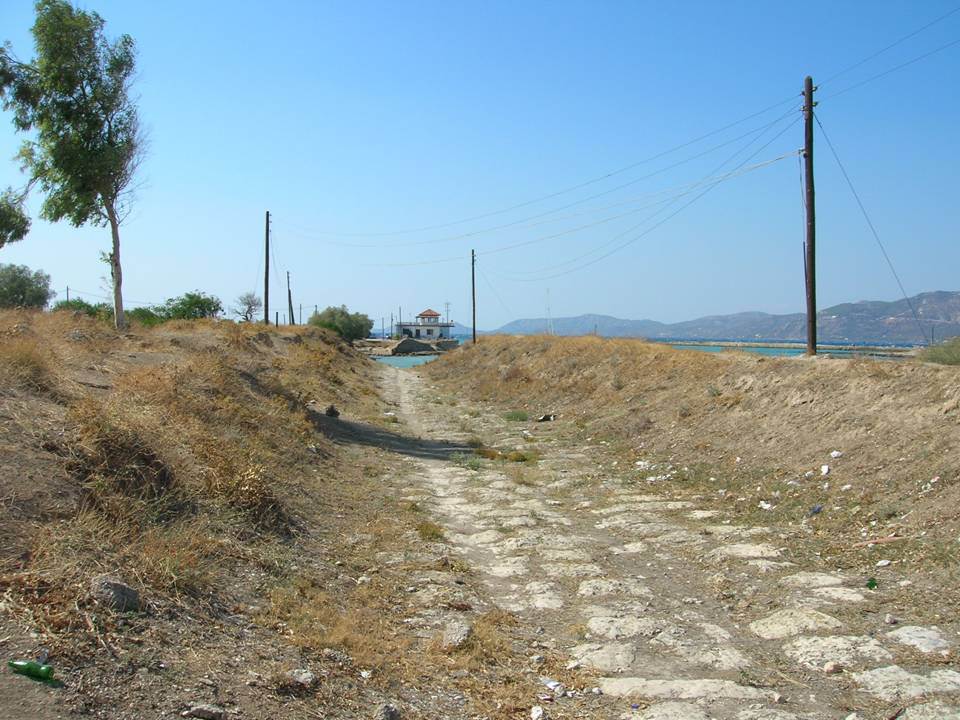
Thucydides, in a famous passage discussing the rise of maritime states (1.13.5), stresses the importance of the Corinthian isthmus not only for maritime commerce but also for overland trade. There is evidence from the 7th-4thcenturies BCE that quarried stone was transported 10-25 miles (Burford). For example, the 8-10 ton column drums from the Corinthia found at Eleusis would have required teams of 20-30 oxen to transport them to port and ship them (Raepsaet). From 1956-59, the Greek archaeologist Nikolaos Verdelis excavated several sections of a limestone roadway, conventionally called the diolcus road (dragging road), extending 1100 meters on the western side of the isthmus that may have been used for moving limestone intended for building temples and other major structures. These sections, not uniform in construction, dimensions, or date, Verdelis proposed originated with the Corinthian tyrant Periander, but more recent assessments date it to the late 5th century (Pettegrew) to late 2nd century BCE (Lohmann). A corresponding road on the eastern side of the isthmus has never been found, perhaps because limestone pavers were not needed on the harder substratum to the east (Lohmann). Nor have archaeological surveys uncovered substantial harbors at either end of the road, although Verdelis did identify one part as a quay on the Gulf of Corinth.
Yet the width of the Corinthian isthmus—roughly 6 km—and its uneven surface—as high as 80 masl and punctuated by ravines—actually make it a barrier to easy passage. Other isthmuses in the eastern Mediterranean, such as at Cnidus or Mimas, Alexandria or Leukas, are much narrower or more easily traversed. Even to unload cargoes and then transport them across the isthmus would have required an enormous amount of logistical coordination, time, and energy. Moving several thousand amphorae loaded with oil (50-70 tons) from a relatively small coastal ship would have required 100-140 oxen and 50-70 wagons (Pettegrew). Moreover, the ceramic evidence found in the Corinthia gives little evidence that cross-isthmian trade from west to east to west ever developed. Lawall has shown that most transport amphorae from the 7th to 1st centuries BCE found to the west of Corinth originate from communities along the Adriatic while those to the east of Corinth belonged to Aegean poleis. Similarly, early Roman pottery is more frequent in Corinth and Patras than Athens and cities in the Aegean while Cenchreae is dominated by eastern wares (Hayes; Rife et al.).
Given the huge natural and physical obstacles to portaging, therefore, crossing the isthmus was not so much about trading cargoes as it was about gaining glory. As early as the 7th century BCE, the Corinthian tyrant Periander attempted to cut a canal through the isthmus (Diogenes Laertius 1.7), and later Demetrius Poliorcetes and the emperor Caligula (Suet. Cal. 21) considered doing the same. In 67 CE, the Roman emperor Nero is the first one to have left any archaeological traces of the effort, all to no effect, although mounds of earth moved by Nero’s attempt are still visible on the western side of the isthmus (Suet. Nero 19.2). At the same time, Vespasian enlisted 6000 Jewish slaves captured at Taricheae in Galilee to provide manpower for Nero’s work (Josephus, Jewish War 3.540), but work was discontinued after 700 meters were excavated. More frequently, ancient writers record the heroic attempts to transport triremes (warships) across the isthmus. The Spartans first endeavored to portage ships across the isthmus during the Peloponnesian War in 428 and 412 BCE (Thucydides 3.15-16; 8.8), followed by Demetrius of Pharos in 220 and Philip V in 217 BCE (Polybius 4.19.7-9; 5.101.4), King Eumenes of Pergamum in 172 BCE (Livy 42.16), and Octavian after the Battle of Actium as he was chasing Antony and Cleopatra to Alexandria (Cassius Dio 51.5).
David Pettegrew argues that, in each case, crossing the isthmus—either by cutting a canal or portaging warships—acts as a rhetorical topos that glorifies the attempt, whether successful or not, as an example of a leader’s daring and ambition and as a marker that isthmus is a pivotal location for strategic action. In each instance, the narrative is quick to point out the hard work and effort of those undertaking the crossing and its extraordinary challenge. Unquestionably, the clearest example of the heroic nature of crossing the isthmus is the crossing of Marcus Antonius, the grandfather of Marc Antony, as he pursued the Cilician pirates in 102-101 BCE (Gebhard and Dickie). Found reused in a Byzantine ramp on the Lechaeum Road, a Latin inscription in elegiac couplets commemorates the event:
The thing that no one has attempted nor [dared],
Learn this affair, that we may carry on with fame the deeds of the man.
Under the auspices of the proconsul [Marcus Antonius,] the fleet
was led across over the isthmus and sent across the sea.
The proconsul himself set sail for Side, the propraetor Hirrus,
because of the time of year, stationed the fleet in Athens.
This deed was finished within a few days with little confusion,
and with great planning and safety.
Anyone who is honest praises the man, and the one who is opposed [is envious].
Let them envy provided that they [perceive] what is right. (CIL1.2.2662)
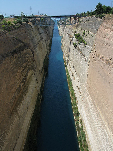
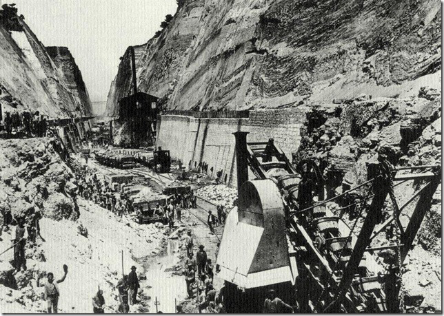
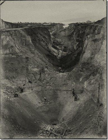
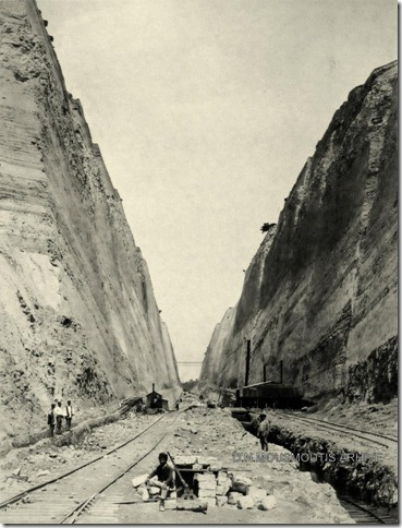
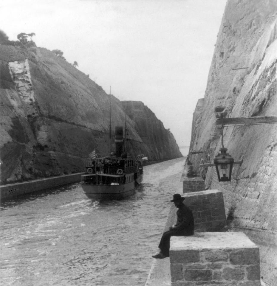
Interestingly, in 2.1.5 Pausanias does not emphasize the heroic nature of crossing the isthmus as much as the divine injunction against violating nature by digging (διορύσσειν) a canal. Although he mentions Alexander the Great’s attempt to dig a canal at Mimas, he refrains from identifying the person who attempted a canal at the isthmus of Corinth. Indeed, he remarks that it is natural (ὡς πεφύκει) that the isthmus remain intact as mainland (ἤπειρος), for it is difficult to act violently (βιάσασθαι) against the gods. It was not until 1893 that a canal, eleven years in the making, was completed permitting traffic and cargoes to cross the isthmus by sea. In these photos and video, you can get a good idea of the amount of earth removed and the depth of the canal.
Works Cited
Isthmia (Corinth) Canal from Chris Downes on Vimeo.
Burford, A. “Heavy Transport in Classical Antiquity.” The Economic History Review 13.1 (1960): 1-18.
Gebhard, Elizabeth, and Matthew Dickie. “The View from the Isthmus, ca. 200-44 B.C.” Corinth: The Centenary, 1896-1996. Ed. C. K. Williams II and N. Bookidis. Princeton: The American School of Classical Studies, 2003. 261-78.
Hayes, J. W. Roman Pottery: Fine Ware Imports. Agora 32. Princeton: American School of Classical Studies, 2008.
Lawall, M. L. “Consuming the West in the East: Amphoras of the Western mediterranean in the Aegean before 86 BC.” Old Pottery in a New Century: Innovating Perspectives on Roman Pottery Studies. Atti del convegno internazionale die studi, Catania 22-24 aprile 2004. Ed. D. Malfitana, J. Poblome, and J. Lund. Catania: Ibam, 2006. 265-85.
Lohmann, H. “Der Diolkos von Korinth—eine antike Schiffsschleppe?” The Corinthia and the Northeast Peloponnesus: Topography and History from Prehistory Until the End of Antiquity. Ed. N. Kissas. Forthcoming.
Pettegrew, David. “The Diolkos of Corinth.” American Journal of Archaeology 115.4 (2011) 549-74.
Raepsaet, G. “Land Transport Part 2: Riding, Harnesses, Vehicles.” The Oxford Handbook of Engineering and Technology in the Classical World. Ed. J. P. Oleson. Oxford: Oxford University Press, 2008. 580-605.
Rife, Joseph L. “Religion and Society at Roman Kenchreai.” Corinth in Context: Comparative Studies on Religion and Society. Edd. S. J. Friesen, D. N. Showalter, and J. C. Walters. Leiden: Brill, 2010. 391-432.
Rife, J., M. Morrison, A. Barbet, R. K. Dunn, D. H. Ubelaker, and F. Monier. “Life and Death at a Port in Roman Greece: The Kenchreai Cemetery Project, 2002-2006.” Hesperia 76 (2007): 143-81.
Sanders, G. D. R. “Urban Corinth: An Introduction.” Urban Religion in Roman Corinth. Ed. D. N. Schowalter and S. J. Friesen. Cambridge, MA: Harvard University Press, 2005. 11-24.
Scranton, Robert L., Joseph W. Shaw, and Leila Ibrahim. Topography and Architecture. Vol. 1 of Kenchreai, Eastern Port of Corinth. Leiden: Brill, 1978.
Verdelis, N. “Der Diolkos am Isthmos von Korinth.” AM 71 (1956) 51-59.
—–. “How the Ancient Greeks Transported Ships over the Isthmus of Corinth: Uncovering the 2550-Year-Old Diolcus of Periander.” ILN (19 Oct 1957): 649-51.
—–. “Die Ausgrabung des Diolkos während der Jahre 1957-1959.” AM 73 (1958): 140-45.
—–. “Ἀνασκαφή τοῦ Διόλκου.” Praktika 1962: 48-50.
Wiseman, James. “Corinth and Rome I: 228 B.C.-A.D. 267.” Aufstieg und Niedergang der römischen Welt 2.7.1 (1979): 438-548.